
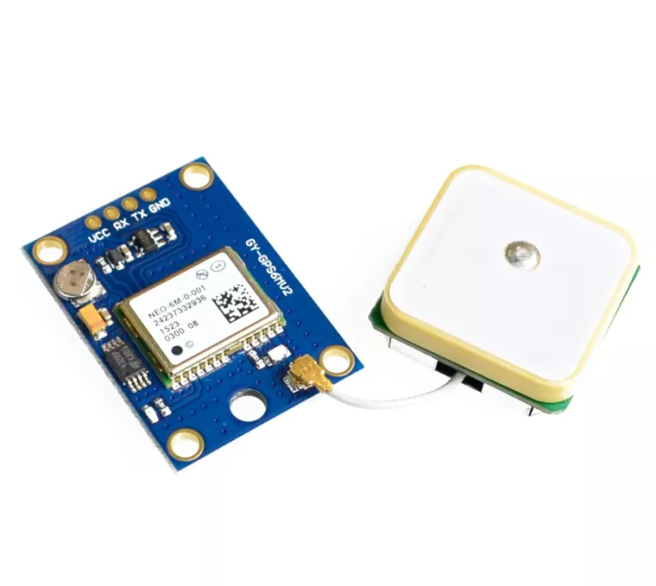
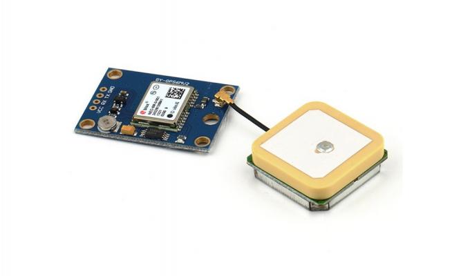
GPS Module GY-NEO-6MV2 Ublox


| รหัสสินค้า | SKU-00556 |
| หมวดหมู่ | โมดูล GSM/GPS |
| ราคา | 220.00 บาท |
| สถานะสินค้า | พร้อมส่ง |
| ลงสินค้า | 16 ก.ย. 2565 |
| อัพเดทล่าสุด | 16 ก.ย. 2565 |
| คงเหลือ | ไม่จำกัด |
| จำนวน | ชิ้น |
หยิบลงตะกร้า

รายละเอียดสินค้า
GPS Module GY-NEO6MV2 Ublox
โมดูล GPS ใช้ระบุตำแหน่งต่างๆบนโลก อ่านค่า ละติจูด ลองจิจูด จากโมดูล GPS ได้
Features:
- Based on u-blox NEO-6M GPS module with on-board backup battery and built-in EEPROM.
- Comes with external U.FL ceramic antenna for better reception.
- It is compatible with various flight controller boards designed to work with a GPS module, APM2.0 and APM2.5 just to name a few.
- This module have built-in voltage regulator and it is sometime referred as GY-GPS6MV2.
- Operating voltage: 3.3V to 5VDC.
- Communication interface: UART TTL, 9600bps.
- LED signal indicator.
- Pin-out for power and interface
- VCC: 3.3 to 5VDC
- RX: Data receive in (input to GPS module)
- TX: Data transmit out (Out from GPS module)
- GND: Ground (Logic and power ground)
- Dimension: 36 x 26 mm.
- Weight: 22g.
____________________________________________________________________________
Arduino uno r3 -> GPS Module GY-NEO6MV2 Ublox
- 5V -> Vcc
- GND -> GND
- ขา4 -> Tx
- ขา3 -> Rx
โหลด Library GPS Module GY-NEO6MV2 Ublox
ให้ต่ออุปกรณ์ตามรูปด้านบน แล้วอัพโหลดโค้ดตัวอย่างด้างล่างลง บอร์ด Arduino uno r3
1
/*
2
* Rui Santos
3
* Complete Project Details https://randomnerdtutorials.com
4
*
5
* Based on the example TinyGPS++ from arduiniana.org
6
*
7
*/
8
9
#include <TinyGPS++.h>
10
#include <SoftwareSerial.h>
11
12
static const int RXPin = 4, TXPin = 3;
13
static const uint32_t GPSBaud = 9600;
14
15
// The TinyGPS++ object
16
TinyGPSPlus gps;
17
18
// The serial connection to the GPS device
19
SoftwareSerial ss(RXPin, TXPin);
20
21
void setup(){
22
Serial.begin(9600);
23
ss.begin(GPSBaud);
24
}
25
26
void loop(){
27
// This sketch displays information every time a new sentence is correctly encoded.
28
while (ss.available() > 0){
29
gps.encode(ss.read());
30
if (gps.location.isUpdated()){
31
// Latitude in degrees (double)
32
Serial.print("Latitude= ");
33
Serial.print(gps.location.lat(), 6);
34
// Longitude in degrees (double)
35
Serial.print(" Longitude= ");
36
Serial.println(gps.location.lng(), 6);
37
38
// Raw latitude in whole degrees
39
Serial.print("Raw latitude = ");
40
Serial.print(gps.location.rawLat().negative ? "-" : "+");
41
Serial.println(gps.location.rawLat().deg);
42
// ... and billionths (u16/u32)
43
Serial.println(gps.location.rawLat().billionths);
44
45
// Raw longitude in whole degrees
46
Serial.print("Raw longitude = ");
47
Serial.print(gps.location.rawLng().negative ? "-" : "+");
48
Serial.println(gps.location.rawLng().deg);
49
// ... and billionths (u16/u32)
50
Serial.println(gps.location.rawLng().billionths);
51
52
// Raw date in DDMMYY format (u32)
53
Serial.print("Raw date DDMMYY = ");
54
Serial.println(gps.date.value());
55
56
// Year (2000+) (u16)
57
Serial.print("Year = ");
58
Serial.println(gps.date.year());
59
// Month (1-12) (u8)
60
Serial.print("Month = ");
61
Serial.println(gps.date.month());
62
// Day (1-31) (u8)
63
Serial.print("Day = ");
64
Serial.println(gps.date.day());
65
66
// Raw time in HHMMSSCC format (u32)
67
Serial.print("Raw time in HHMMSSCC = ");
68
Serial.println(gps.time.value());
69
70
// Hour (0-23) (u8)
71
Serial.print("Hour = ");
72
Serial.println(gps.time.hour());
73
// Minute (0-59) (u8)
74
Serial.print("Minute = ");
75
Serial.println(gps.time.minute());
76
// Second (0-59) (u8)
77
Serial.print("Second = ");
78
Serial.println(gps.time.second());
79
// 100ths of a second (0-99) (u8)
80
Serial.print("Centisecond = ");
81
Serial.println(gps.time.centisecond());
82
83
// Raw speed in 100ths of a knot (i32)
84
Serial.print("Raw speed in 100ths/knot = ");
85
Serial.println(gps.speed.value());
86
// Speed in knots (double)
87
Serial.print("Speed in knots/h = ");
88
Serial.println(gps.speed.knots());
89
// Speed in miles per hour (double)
90
Serial.print("Speed in miles/h = ");
91
Serial.println(gps.speed.mph());
92
// Speed in meters per second (double)
93
Serial.print("Speed in m/s = ");
94
Serial.println(gps.speed.mps());
95
// Speed in kilometers per hour (double)
96
Serial.print("Speed in km/h = ");
97
Serial.println(gps.speed.kmph());
98
99
// Raw course in 100ths of a degree (i32)
100
Serial.print("Raw course in degrees = ");
101
Serial.println(gps.course.value());
102
// Course in degrees (double)
103
Serial.print("Course in degrees = ");
104
Serial.println(gps.course.deg());
105
106
// Raw altitude in centimeters (i32)
107
Serial.print("Raw altitude in centimeters = ");
108
Serial.println(gps.altitude.value());
109
// Altitude in meters (double)
110
Serial.print("Altitude in meters = ");
111
Serial.println(gps.altitude.meters());
112
// Altitude in miles (double)
113
Serial.print("Altitude in miles = ");
114
Serial.println(gps.altitude.miles());
115
// Altitude in kilometers (double)
116
Serial.print("Altitude in kilometers = ");
117
Serial.println(gps.altitude.kilometers());
118
// Altitude in feet (double)
119
Serial.print("Altitude in feet = ");
120
Serial.println(gps.altitude.feet());
121
122
// Number of satellites in use (u32)
123
Serial.print("Number os satellites in use = ");
124
Serial.println(gps.satellites.value());
125
126
// Horizontal Dim. of Precision (100ths-i32)
127
Serial.print("HDOP = ");
128
Serial.println(gps.hdop.value());
129
}
130
}
131
}
____________________________________________________________________________
ตัวอย่างการใช้งาน NEO-6M Ublox/u-blox GPS Module
โคดไลบารีแสดงพิกัด lat , lon ดาวน์โหลดได้ที่นี่
https://github.com/LessonStudio/Arduino_GPS
#include "TinyGPS++.h"
#include "SoftwareSerial.h"

SoftwareSerial serial_connection(10, 11); //RX=pin 10, TX=pin 11
TinyGPSPlus gps;//This is the GPS object that will pretty much do all the grunt work with the NMEA data
void setup()
{
Serial.begin(9600);//This opens up communications to the Serial monitor in the Arduino IDE
serial_connection.begin(9600);//This opens up communications to the GPS
Serial.println("GPS Start");//Just show to the monitor that the sketch has started
}

void loop()
{
while(serial_connection.available())//While there are characters to come from the GPS
{
gps.encode(serial_connection.read());//This feeds the serial NMEA data into the library one char at a time
}
if(gps.location.isUpdated())//This will pretty much be fired all the time anyway but will at least reduce it to only after a package of NMEA data comes in
{
//Get the latest info from the gps object which it derived from the data sent by the GPS unit
Serial.println("Satellite Count:");
Serial.println(gps.satellites.value());
Serial.println("Latitude:");
Serial.println(gps.location.lat(), 6);
Serial.println("Longitude:");
Serial.println(gps.location.lng(), 6);
Serial.println("Speed MPH:");
Serial.println(gps.speed.mph());
Serial.println("Altitude Feet:");
Serial.println(gps.altitude.feet());
Serial.println("");
}
}
- http://www.instructables.com/id/Arduino-Ublox-GPS/
วิธีการชำระเงิน
ร้านค้านี้ยังไม่ได้กำหนดวิธีการชำระเงิน กรุณา ติดต่อกับทางร้าน เกี่ยวกับรายละเอียดในการชำระเงิน
ทางร้านยังไม่ได้ทำการเพิ่มบัญชีรับเงิน กรุณาติดต่อ เจ้าของร้าน
AFFILIATION

MEMBER

▲
▼
รายการสั่งซื้อของฉัน
รายการสั่งซื้อของฉัน
ข้อมูลร้านค้านี้

บ้านโค้ด-Bancode
จำหน่ายบอร์ดไมโครคอนโทรลเลอร์ Arduino,Module,Shield,Sensor,R,L,C,IC เเละอื่นๆ โทร.0624952525
เบอร์โทร : 0964188828
อีเมล : bancode.dev@gmail.com
อีเมล : bancode.dev@gmail.com
ส่งข้อความติดต่อร้าน
เกี่ยวกับร้านค้านี้
ค้นหาสินค้าในร้านนี้
ค้นหาสินค้า
สินค้าที่ดูล่าสุด
บันทึกเป็นร้านโปรด
Join เป็นสมาชิกร้าน
แชร์หน้านี้
แชร์หน้านี้
↑
TOP เลื่อนขึ้นบนสุด
TOP เลื่อนขึ้นบนสุด
สินค้าในตะกร้า ({{total_num}} รายการ)

ขออภัย ขณะนี้ยังไม่มีสินค้าในตะกร้า
ราคาสินค้าทั้งหมด
฿ {{price_format(total_price)}}
- ฿ {{price_format(discount.price)}}
ราคาสินค้าทั้งหมด
{{total_quantity}} ชิ้น
฿ {{price_format(after_product_price)}}
ราคาไม่รวมค่าจัดส่ง
➜ เลือกซื้อสินค้าเพิ่ม